Sunday, September 30, 2018

Module 5a - Intro to ERDAS Imagine & Digital Data


This week in lecture we learned about Electromagnetic Radiation (EMR), models of EMR focusing on the Wave model, Electromagnetic Spectrum, EMR interactions of refraction, scattering, absorption, reflectance and transmission.

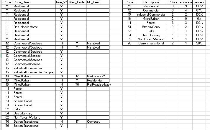
In lab this week we were exposed to ERDAS Imagine for the first time.  We used basic tools to add data, fit to frame, adjust vector symbology, navigate the image, set default data directory and default output directory, and changed band combinations to examine enhancements.  The project we added an area column in the attribute table in ERDAS, selected a small area of image utilizing the inquire box and created a subset of the image from the inquire box and saved to output as .img.  The .img was opened in Arc Pro and the above map created to show the classes within my subset and the area of each of classes.

Saturday, September 22, 2018

Module 4: Ground Truthing and Accuracy Assessment

This week in lab we took our LULC map from last week and performed ground truth via Google Map.  I randomly selected 30 points in a grid fashion and then adjusted to account for each land type from the original map.  Each point was located and verified in google map for the location land use.  Here is a summary table of those results.


Of the 30 sample points 24 of them were classified correctly for an overall accuracy of 80%.  The smaller table above shows the accuracy broken out by classifications.  Mixed Urban had 0% correct.  Since I utilized this class for areas that I could not completely identify when classifying it is reasonable that with additional data the need for this classification would be eliminated.

Sunday, September 16, 2018

Land Use Land Cover Classification

This week in lab we practiced our skills of recognizing features on the ground using a natural color aerial photograph.  We digitized an area of Pascagoula, MS, creating a land use/land cover map.  We identified the ground based on size, shape, color, pattern, shadows and association.  We utilized the USGS Standard Land Use / Land Cover Classification System.  The assignment was to categorize to level two (two digit classification).  Classifications of three or higher are typically utilized for local and some regional planning. 

My specific categories for this project 
Part of my employment background was working for 10 years in a building department in a municipality.  We worked very closely with the planning department and GIS guy.  Identifying urban land use from aerial perspectives I have done before.  It is a lot easier when you are familiar with the area.  Correctly identifying natural elements just at a level 2 classification was difficult because I am not familiar with the difference in kinds of trees or when a stream or canal becomes part of an estuary or bay. 
Technically doing the polygons was new and still somewhat challenging in the new to me GIS Pro.  My first attempt I did not have the Edge snapping or vertex snapping turned on, so I utilized this attempt as practice.  The second attempt I did turn on the snapping features while creating the polygons.  First creating a feature class file in my gdb.  Then in the edit tab clicking the create button and choosing polygon.  It was challenging to be able to navigate the picture while creating the polygon.  I settled on zooming in and out with the mouse scroll to move the image without having to click.  I did not master the clip portion to separate smaller interior polygons from larger surrounding areas.  Instead I relied on more of a lasso method with the larger polygon.  I started with larger easily identified areas keeping my attribute table open and adding the code as I drew each polygon (realizing that you must click off the cell in the attribute table that you are making changes to before you save the changes or that cell will not be recorded).  As I progressed from larger isolated polygons then I started working right and left back and forth to fill in the surrounding areas and smaller isolations.  Distinguishing between commercial service and commercial industrial was harder without knowledge of the practice of the location.  Ultimately, I settled on cleaner sites without outside materials or industrial roof or ground mechanisms and Commercial Service and those with as Commercial Industrial.

Sunday, September 9, 2018

Visual Interpretation


This week in Photo Interpretation and Remote Sensing we  learned more about the types of and techniques for interpreting aerial photography. We were provided background on the types of aerial cameras, the different types of images they capture (oblique, vertical, stereo), the types of film used by traditional cameras, and understand how resolution (spatial, spectral, temporal) applies to aerial photography. We also learned concepts, techniques, and application of visually interpreting aerial photos. We learned about the methods and techniques used to visually interpret aerial photos (i.e. recognition elements). These techniques form the basis for deriving geographic features and/or land use land cover types from aerial photos and that are used in a wide variety of real world applications. 
In the laboratory exercise, we learned some basic principles of interpreting features found on aerial photographs.  The first map above illustrates ranges of tone and texture for this photo.  The second map above demonstrates examples of elements identified, at least partially, by shape and size, pattern, shadow, and association of the surroundings.  We also examined a true color image (blue, green, red), identifying 5 areas of color and compared those elements in the same image provided in false color (green, red, and infrared).
We have moved from ArcGIS desktop to ArcGIS Pro and it has been a disorienting week.  The changes are vast! location of symbology, labeling, and properties are different, but even the environment has changed to a project oriented system instead of .mdx maps.  I am sure I will catch up as soon as I figure out how to control drive location.