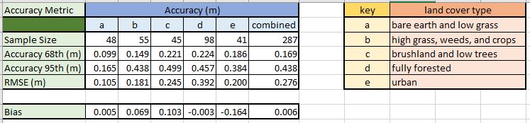
This week we examined vertical accuracy of DEMs. We were provided with a raster file of high resolution bare earth DEM obtained through LIDAR and and excel file with field observations of ground elevation. The field data contained 5 land cover types (a-e). We utilized the Extract Multi Values to Points tool. This tool grabs the elevation value of the pixel of the lidar raster directly beneath each sample point. We added a field to the attribute table to convert feet to meters. Accuracy was calculated for each land cover type and then the all the data combined. We summarized the comparison in the table above. The calculations in the table are the differences in meters from the DEM to the reference field data at 68%, 95%, RMSE, and Bias.
RMSE
- difference between DEM and reference for each point
- Square the difference for each point
- Average the squared differences (Sum the square difference/count of points)
- Square root of the average
Bias as ME - is the average of the errors
No comments:
Post a Comment