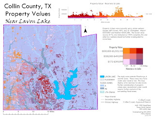
My second infographic includes a scatter plot and bivariate choropleth. The scatter plot displays distance to lake on the x axis and property values on the y axis. The bivariate choropleth displays property value in a 3 class manual display (< $300,000 = 48.0%, $300,000-$500,00 = 40.0% and above $500,000 11.8%) and nearness to Lavon Lake in a 3 class quantile class (rounded to whole numbers: <8 miles = 36.68%, 8-12 miles = 31.5%, more than 12 miles = 31.82%). The two variable legend classes from lower left as furthest from the lake (more than 12 miles and lowest property values at under $300,000. to the highest lass upper right with nearest to the lake (within 8 miles) and property values over $500,000. This display would indicate there is not a significant correlation between the two variables. This may be due to the floodplain in the area containing floodways that may contain year round navigable waters, allowing access to recreational waters in areas other than the lake.
Friday, March 1, 2019
Final Project: Collin County Residential Property Value
My final project for Communicating GIS 6005 was to examine limited variables correlation to single family property values in Collin County, Texas. The variables considered were number of bedrooms, number of bathrooms, age of property and nearness to Lavon Lake. Shapefiles for Lavon Lake boundary, Collin County boundary, roads, and floodplain boundary were obtained from Collin County. Parcel data was obtained from Collin County Appraisal District. The above infographic contains scatter plots for property value on the x axis and number of bathrooms (top) and number of bedrooms (bottom). The age of the properties are displayed on purple with a black to white color ramp displaying oldest to newest properties. The main display is of assessed property values shown on a color ramp from dark blue to bright yellow (low-high). The main display also includes the floodplain for the area. Finally in the main display, low in the hierarchy, are primary highways, secondary highways and major arterial roads. Parcel data was limited to single family residential that were 100% complete and contained information on bathrooms, bedrooms and assessed property value. Data should be further examined as the property values range from 172 to over $5.5 million. Those properties of very low values should be examined for error.
Subscribe to:
Comments (Atom)

